|

|
Starting point:
|
|
You can park your car and start rowing from Nibe Rowing Club, Aalborgvej 1, 9240 Nibe by appointment. Contact them over email at This email address is being protected from spambots. You need JavaScript enabled to view it.. There are several places with free parking close to the water at Nibe Habour, Bryggen, 9240 Nibe.
|
Ending point:
Same as above. Alternatively at Halkær Bredning: Sebbersund, Parkering Navet, Navet 48, 9240 Nibe or Halkær old fortification (Halkærvej 74, 9240 Nibe).
|
Difficulty:
|
| Easy |
Special conditions:
|
|
The water level is very shallow at several places from Nibe and southward.
|
Protection and considerations:
|
|
Halkær Bredning is an international nature reserve under Natura 2000. Be careful not to disturb the birds and fauna. Klosterholm is closed from the 1.4 - 15.7.
|
Facilities:
|
Accommodation:
- Nibe Camping Sølyst, Løgstørvej 2, 9240 Nibe, Tlf +45 98 35 10 62, check www.soelyst.dk-camp.dk. The campsite is located right by the water with a jetty and sandy beach to enter from. They also have cabins. (GPS: 56.973044°N, 9.622291°E)
- Nature campsite at Halkær Å (Halkær old fortification): Halkjærvej 74, 9240 Nibe - This email address is being protected from spambots. You need JavaScript enabled to view it. (GPS: 56,917962°N, 9.574776°E)
- 3 shelters accommodating up to 15 people. Campfire. Access to water during the summer half. There is a small berth where the kayak can be taken out of the water. About 150 m to the campsite. (GPS: 56.876168°N, 8.629706°E)
Toilets/shower:
- Nibe Camping Sølyst, Løgstørvej 2, 9240 Nibe, Tlf +45 98 35 10 62. Check www.soelyst.dk-camp.dk (GPS: 56.973044°N, 9.622291°E)
- Nibe Harbour: Bryggen, 9240 Nibe. Drinking water, toilets, and showers are available for a fee (GPS: 56.988748°N, 9.633851°E)
Where to eat:
Shopping:
- Nibe Camping Sølyst, Løgstørvej 2, 9240 Nibe. Smaller selection of groceries (GPS: 56.972715°N, 9.624849°E)
- Nibe: Fakta – About 500 m south of the habour: Toften 9, 9240 Nibe. Supermarket. (GPS: 56.984702°N, 9.639508°E)
Landing Spots:
- Sebbersund at the small harbour (Navet) (GPS: 56.960937°N, 9.571339°E)
- Nibe Camping – Sølyst, Løgstørvej 2, 9240 Nibe (GPS: 56.973059°N, 9.622327°E)
- Nibe Harbour, Bryggen, 9240 Nibe (GPS: 56.988801°N, 9.633356°E)
- Halkær old fortification, Halkærvej 74, 9240 Nibe (GPS: 56.917205°N, 9.577924°E)
Kayak Rentals:
None |
Tour Description:
|
|
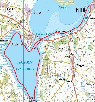
Starting at Nibe, you row south-west. You will have to go a bit out in the water in order to get water under the kayak. The water level is very low close to the beach (check the kayak map). There are marshes and rich bird life to look for. After about 4 km, you will arrive at the Sebbersund Dam. You can row through the dam and into Halkær Bredning. The trip around Halkær Bredning is about 12 km long and 4 hours should be sufficient to both make the trip and enjoy nature. To the west, not far from the dam, you can see the idyllic harbour at Sebbersund. Further along the coast to the west, there is beautiful nature with trees and hills to look for before you, after about 7 km, reach the entry point to Halkær Å. Before you reach the mouth of Halkær Å, there is a large sandbar and you will have to row about 200 m to the right in order to go further up the stream. Halkær Å is very popular among anglers because of the many trouts in the stream. There is a landing spot with a shelter about 1200 m up the stream, where you can spend the night. Here you can also go for a walk to the Halkær Nature Centre and the restored Halkær Lake. The 1200 m trip up Halkær Å is very idyllic. After a rest, you can then row back to Nibe. The east side of Halkær Bredning is also beautiful.
It is possible to row all the way to Vegger in Halkær Å (there are 4 bridges on the way that require you to duck a lot). The trip from the mouth of Halkær Å to Vegger is about 4 km. Usually, it can only be done during the first half of the year, as there is a lot of weed and rush post-July. The trip is very beautiful for its nature and the many grey herons, jumping trouts, otters, kingfishers and other exciting wildlife. Motorboats are strictly forbidden. The trip is well-suited for beginners because of the relatively protected water.
|
Attractions:
|
- Halkær Mill Nature Centre – check http://naturstyrelsen.dk/naturoplevelser/naturguider/halkaer-moelle. Located about 300 m from the shelter at Halkær Å (GPS: 56,917962°N, 9.574776°E)
- Halkær Lake (restored) – Located at the Halkær Mill Nature Centre. Here is a bird tower (GPS: 56.915779°N, 9.579604°E)
|
Links:
|
|
www.visitaalborg.dk
|
|